Reality capture works by collecting precise measurements of physical spaces and objects using advanced technologies like laser scanning and photogrammetry. This process creates detailed digital representations that can be used for planning, analysis, and decision-making across industrial and construction projects. The captured data is transformed into 3D models, point clouds, and digital twins that provide accurate information for various applications.
What is reality capture and how does it actually work?
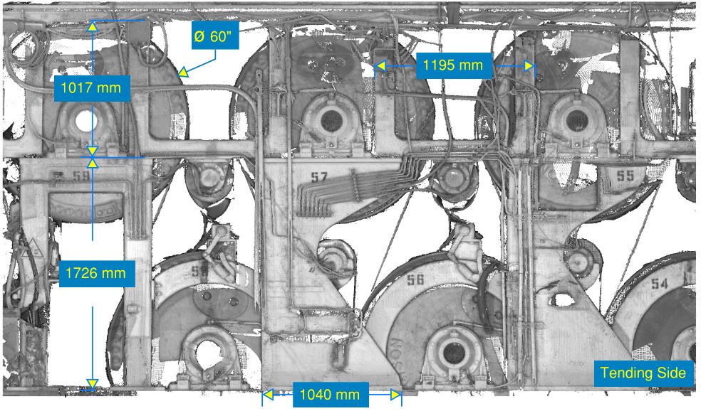
Reality capture is a process that creates digital copies of real-world environments through precise measurement technologies. Laser scanning and photogrammetry capture millions of data points to build accurate 3D representations of spaces, structures, and objects.
The process begins with specialized equipment scanning the target area. Laser scanners emit light pulses that bounce back from surfaces, measuring distances with millimetre precision. These measurements create dense point clouds containing spatial coordinates for every surface detail. Photogrammetry complements this by taking overlapping photographs from multiple angles, which software then processes to extract dimensional information.
Modern reality capture combines these technologies to produce comprehensive datasets. The equipment automatically registers multiple scan positions, creating seamless digital models of entire facilities or construction sites. This approach ensures that no detail is missed while maintaining survey-grade accuracy throughout the captured area.
What types of technology are used in reality capture projects?
Industrial laser scanning uses terrestrial laser scanners that capture detailed interior and exterior measurements of industrial facilities. Mobile scanning systems mounted on vehicles or carried by operators can cover large areas efficiently while maintaining the precision standards required for engineering applications.
Drone-based systems extend reality capture capabilities to areas that are difficult or dangerous to access. These aerial platforms carry high-resolution cameras and lightweight laser scanners, making them particularly valuable for construction laser scanning projects involving tall structures or expansive construction sites.
Photogrammetry equipment ranges from professional cameras to specialized stereo systems that capture overlapping images for 3D reconstruction. When combined with laser scanning data, these systems provide both geometric accuracy and visual detail that support comprehensive project documentation and analysis.
Ground control points and GPS systems ensure all captured data aligns with real-world coordinates. This integration allows different scanning sessions and technologies to work together, creating unified datasets that support accurate measurements and reliable project planning.
How do you prepare for a reality capture project?
Preparation starts with defining project objectives and identifying which areas need to be captured. This planning phase determines the appropriate scanning density, accuracy requirements, and delivery formats needed for your specific application, whether it is laser scanning for investment projects or operational documentation.
Site assessment involves evaluating access routes, safety requirements, and environmental conditions that might affect data collection. Scanning teams need clear pathways between scan positions and must account for lighting conditions, weather, and any operational constraints that could impact the capture process.
Coordinate systems and reference points are established before scanning begins. This preparation ensures the captured data integrates properly with existing drawings, models, or geographic information systems. Clear communication with site personnel helps coordinate timing and access while maintaining normal operations.
Equipment selection depends on the project scope and accuracy requirements. Large industrial facilities might need multiple scanner types and positions, while smaller spaces can often be captured with a single setup. Planning scan positions and overlap ensures complete coverage without gaps in the final dataset.
What happens to the data after it’s captured?
Raw scan data undergoes processing to remove noise, align multiple scan positions, and create unified point clouds. This laser scanning and reality capture workflow transforms millions of individual measurements into coherent 3D models that accurately represent the scanned environment.
Point cloud data can be converted into various formats depending on project needs. CAD models, mesh surfaces, and digital twins each serve different purposes, from detailed engineering analysis to visual presentations and virtual reality applications. The processing workflow maintains accuracy while optimizing file sizes for practical use.
Quality control procedures verify measurement accuracy and completeness throughout the processing workflow. This includes checking point cloud density, verifying dimensional accuracy against known references, and ensuring all required areas have been captured with sufficient detail for the intended applications.
Final deliverables typically include processed point clouds, extracted drawings, 3D models, and measurement reports. These outputs integrate with existing project workflows, supporting everything from as-built documentation to investment planning and facility management systems.
Reality capture technology continues to advance rapidly, with new applications emerging across industries. The combination of precise measurement capabilities and digital workflow integration makes this technology increasingly valuable for projects requiring accurate spatial information. When you need reliable measurement data for industrial or construction applications, we at N1digital specialise in delivering comprehensive reality capture solutions that support informed decision-making throughout your project lifecycle. For expert guidance on your next project, please get in touch with our team.