Laser scanning data is visualized through specialized software that transforms point cloud measurements into viewable 3D models, digital twins, and interactive visualizations. The process involves converting millions of precise coordinate points into formats that teams can understand, analyze, and use for decision-making. Different visualization types serve specific project needs, from basic point clouds to fully integrated BIM models.
What exactly is laser scanning data and why does visualization matter?
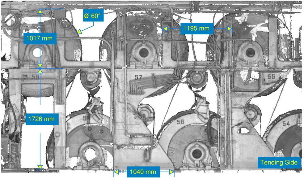
Laser scanning data consists of point clouds—millions of precise 3D coordinate points captured by laser measurement devices. Each point represents an exact location in space with X, Y, and Z coordinates, creating a highly accurate digital representation of physical objects, buildings, or industrial facilities.
The raw data appears as dense collections of colored dots when viewed in specialized software. Without proper visualization, this information remains difficult to interpret and use effectively. Industrial facilities and construction projects generate particularly complex datasets that require clear visual representation for meaningful analysis.
Visualization transforms these coordinate points into understandable formats that project teams can work with. You can identify structural details, measure distances, detect changes over time, and plan modifications when the data is properly displayed. This visual clarity is especially important for industrial laser scanning projects where precision matters for operational decisions.
Modern reality capture techniques produce datasets containing hundreds of millions of points. Teams need efficient visualization methods to extract useful information from this wealth of measurement data without becoming overwhelmed by technical complexity.
How do you turn raw point cloud data into visual models?
The visualization process begins with data processing workflows that clean, organize, and convert raw laser scanning measurements into viewable formats. Professional software imports the point cloud data and applies filtering, alignment, and enhancement techniques to create clear visual representations.
Initial processing involves removing noise, aligning multiple scan positions, and organizing the data structure. Software tools then apply color mapping, intensity values, and surface detection algorithms to make the point cloud more visually comprehensible. This stage prepares the foundation for more advanced visualization types.
Creating 3D models from point clouds requires mesh generation or surface reconstruction techniques. The software identifies patterns in the point data and builds continuous surfaces that represent walls, equipment, pipes, and other physical features. This process transforms discrete measurement points into solid-looking objects.
Advanced processing can generate digital twins that combine geometric accuracy with additional data layers. These comprehensive models integrate the precise measurements from laser scanning with operational information, creating interactive visualizations that support both planning and ongoing facility management.
What types of visualizations can you create from laser scanning data?
Point cloud visualizations display the raw measurement data as colored 3D points that show precise geometric details. This format works well for initial data review, quality checking, and situations where maximum measurement accuracy is required for analysis and documentation.
Mesh models convert point clouds into continuous surfaces with triangulated faces. These visualizations look more like traditional 3D objects and integrate easily with CAD software. Mesh models suit projects requiring smooth visual representation while maintaining geometric accuracy from the original laser measurements.
Digital twins represent the most comprehensive visualization approach, combining accurate geometry with operational data and interactive capabilities. These models support real-time monitoring, predictive maintenance planning, and strategic decision-making for industrial facilities throughout their operational lifecycle.
BIM integration allows laser scanning data to become part of Building Information Modeling workflows. The visualizations include both geometric accuracy and project information, supporting construction industry laser scanning applications where coordination between design teams, contractors, and facility managers is required.
Specialized visualization formats include cross-sections, elevation views, and measurement overlays that highlight specific aspects of the scanned environment. These targeted visualizations help teams focus on particular elements without visual distraction from unnecessary details.
Which software tools work best for laser scanning visualization?
Professional point cloud software provides specialized visualization capabilities designed specifically for laser scanning data. These applications handle large datasets efficiently while offering tools for measurement, analysis, and model creation that generic 3D software cannot match.
CAD integration software bridges the gap between point cloud data and traditional design workflows. These tools allow teams to work with laser scanning visualizations alongside existing drawings and models, supporting projects where new measurements need to integrate with established design processes.
Web-based visualization platforms enable teams to share and collaborate using laser scanning data without requiring specialized software installations. These solutions work particularly well for stakeholder communication and project coordination where team members need access to visual information but not advanced analysis capabilities.
Industry-specific software addresses particular visualization needs for different sectors. Manufacturing applications focus on precision measurement and quality control visualization, while construction-oriented tools emphasize BIM integration and project coordination capabilities.
The choice depends on your project requirements, team capabilities, and integration needs with existing workflows. Consider data size limitations, collaboration requirements, and the level of analysis functionality needed when selecting visualization software for laser scanning investment projects.
How do you share and collaborate with laser scanning visualizations?
Cloud-based platforms provide secure access to laser scanning visualizations without requiring specialized software installations. Team members can view, measure, and annotate 3D models through web browsers, enabling collaboration across different locations and organizations involved in the project.
File format selection affects how easily you can share visualizations with different stakeholders. Standard formats like 3D PDF, IFC, and common mesh formats ensure compatibility with various software tools, while proprietary formats may offer better functionality but limit accessibility for some team members.
Project management integration connects laser scanning visualizations with scheduling, documentation, and communication workflows. This approach keeps visual data aligned with project timelines and ensures that measurement information supports decision-making throughout the project lifecycle.
Mobile access allows field teams to reference laser scanning visualizations on-site during construction or maintenance activities. Tablet and smartphone applications provide convenient access to measurement data and visual references when teams need to verify conditions or plan work activities.
Version control becomes important when multiple team members work with the same visualization data. Proper data management ensures that everyone accesses current information and that changes are tracked appropriately throughout the project development process.
Understanding laser scanning data visualization opens up powerful possibilities for industrial and construction projects. The combination of precise measurement capture through laser scanning and reality capture with effective visualization techniques creates valuable tools for planning, analysis, and decision-making. We help organizations transform their measurement data into clear, actionable visualizations that support better project outcomes and operational efficiency through our comprehensive laser scanning services. For specific project requirements and visualization needs, teams can request a detailed project quote to explore customized solutions.