Laser scanning creates digital twins by capturing millions of precise data points from physical assets, buildings, and infrastructure to build accurate 3D digital representations. These digital twins serve as virtual replicas that support planning, optimization, and decision-making across industries. Laser scanning technology enables organizations to visualize, analyze, and manage their physical assets digitally throughout their entire lifecycle.
What exactly are digital twins and how does laser scanning create them?
Digital twins are precise virtual replicas of physical assets, buildings, or infrastructure that mirror their real-world counterparts in three dimensions. Laser scanning creates these digital twins by using reality capture technology that emits laser pulses to measure distances and capture millions of data points from physical surfaces.
The laser scanning process works by systematically scanning physical spaces and objects to create point cloud data. This data captures every detail of the physical environment, including dimensions, surfaces, and spatial relationships. The resulting point cloud serves as the foundation for building accurate 3D models that represent the physical asset digitally.
Industrial laser scanning transforms this raw scanning data into comprehensive digital models through specialized software that processes point clouds and converts them into usable 3D representations. These digital twins maintain the precise measurements and spatial accuracy of the original physical assets, making them reliable tools for analysis and planning.
What types of digital twins can you create with laser scanning technology?
Laser scanning enables the creation of several distinct categories of digital twins, each serving specific applications and industries. Building twins represent architectural structures, facilities, and interior spaces with complete accuracy for facility management and renovation planning.
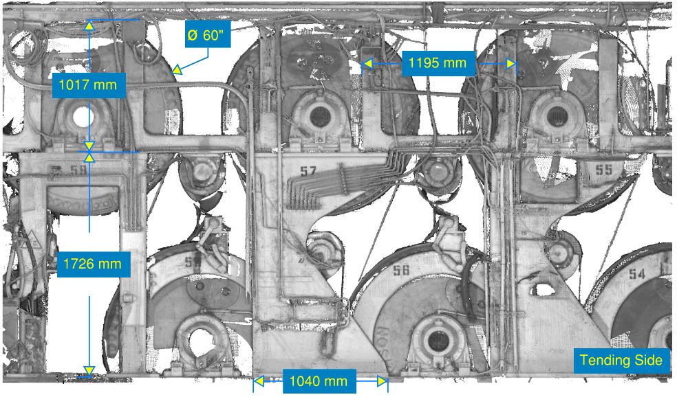
Industrial facility twins capture complex manufacturing environments, production lines, and process equipment. Construction laser scanning creates comprehensive models of construction sites, existing buildings, and infrastructure projects that support BIM processes and project coordination.
Equipment twins focus on individual machinery, systems, or components within larger facilities. These detailed models support maintenance planning, reverse engineering, and equipment optimization. Infrastructure twins encompass larger-scale assets like bridges, roads, utilities, and transportation networks.
Each type of digital twin serves different purposes, from operational monitoring and maintenance scheduling to strategic planning and investment decision-making. The right choice depends on your specific requirements and the physical assets you need to manage digitally.
How accurate are digital twins created from laser scanning data?
Digital twins created through laser scanning typically achieve millimeter-level accuracy, with precision depending on the scanning equipment and methodology used. Professional laser scanning systems can capture measurements with accuracy ranging from 1–5 millimeters, providing reliable data for critical decision-making processes.
Several factors influence the accuracy of laser scanning-based digital twins. Distance from the scanner affects precision, with closer objects captured more accurately than distant ones. Environmental conditions, surface materials, and scanning resolution settings also impact the final accuracy of the digital twin.
This high level of precision supports confident planning and analysis across various applications. Laser scanning for investment projects relies on this accuracy to ensure that investment decisions are based on reliable measurements and spatial data.
The measurement precision enables organizations to trust their digital twins for operational planning, compliance verification, and strategic decision-making. This accuracy proves particularly valuable when planning modifications, expansions, or optimization projects where precise measurements are essential.
What industries benefit most from laser scanning-based digital twins?
Manufacturing and process industries gain significant value from laser scanning digital twins for facility optimization, equipment planning, and maintenance management. These industries use digital twin technology to visualize complex production environments and plan improvements without disrupting operations.
Construction and architecture sectors use construction laser scanning extensively for project planning, progress monitoring, and BIM integration. Digital twins support accurate project coordination, clash detection, and renovation planning by providing precise existing-condition documentation.
Facility management organizations benefit from digital twins for space planning, maintenance scheduling, and asset management. The technology enables better understanding of building systems, space utilization, and infrastructure maintenance needs.
Infrastructure development projects rely on laser scanning digital twins for planning transportation networks, utilities, and public infrastructure. These applications require high accuracy and comprehensive documentation that traditional surveying methods cannot efficiently provide.
How do you actually create a digital twin using laser scanning?
Creating a digital twin begins with comprehensive data capture using professional laser scanning equipment positioned strategically throughout the target area. Multiple scan positions ensure complete coverage of all surfaces and eliminate shadow areas that single scans might miss.
The scanning process generates point cloud data that requires processing and registration to align multiple scans into a single, cohesive model. Specialized software combines these point clouds and removes noise or irrelevant data points to create clean, accurate representations.
Point cloud processing involves converting raw scanning data into structured 3D models through various techniques, including meshing, surface reconstruction, and geometric modeling. This stage transforms the point cloud into a usable digital twin format suitable for analysis and visualization.
The final implementation phase involves integrating the digital twin into appropriate software platforms and systems where users can access, analyze, and use the model. Data management systems enable secure storage, sharing, and ongoing updates to maintain the digital twin’s relevance and accuracy over time.
We specialize in transforming physical environments into accurate digital twins through professional laser scanning services and comprehensive digital modeling solutions. Our expertise in reality capture and 3D modeling helps organizations leverage precise digital representations for improved planning, optimization, and decision-making throughout their asset lifecycles. Request a quote today.