Capture assets in a digital form
Reality capture
Reality capture refers to the process of capturing real-world objects, scenes, or environments in digital form, often using various technologies such as 3D scanning, photogrammetry, laser scanning, or depth sensing. The goal is to create accurate and detailed digital models, that can be used for a wide range of applications, including visualization, documentation, analysis, and simulation.
Our methods
How do we do it?
Laser scanning
Aso known as 3D laser scanning or LiDAR scanning. Click below to read more.
Terrestrial scanning
Also known as terrestrial laser scanning or terrestrial LiDAR scanning.
Mobile scanning
Also known as mobile LiDAR scanning or mobile LiDAR mapping.
Photogrammetry
Extracting 3D information of objects, landscapes, or environments.
Drones
Applications
Who can utilize reality capture?
Reality capture has numerous applications across various industries, such as:
- Architecture, Engineering, and Construction (AEC): Reality capture is used to create accurate as-built documentation, plan renovations, and visualize design concepts.
- Heritage Preservation: Capturing historical sites and artifacts helps in preservation, documentation, and virtual reconstruction of cultural heritage.
- Entertainment and Gaming: Reality capture is used to create realistic and immersive environments, characters, and assets for video games and movies.
- Virtual and Augmented Reality (VR/AR): 3D models generated through reality capture contribute to more realistic and interactive VR/AR experiences.
- Industrial Design and Manufacturing: Reality capture assists in reverse engineering, prototyping, and quality control processes.
- Urban Planning and Environmental Studies: Reality capture enables the analysis of cityscapes and landscapes for better urban planning and environmental monitoring.
Creating digital assets
Point clouds and their usage
A point cloud is a collection of 3D data points that represent the surfaces of objects or the geometry of a real-world environment. Each point in the point cloud has X, Y, and Z coordinates, which define its position in a 3D Cartesian coordinate system. Point clouds are a common output of various reality capture techniques, such as laser scanning, photogrammetry, and LiDAR, and they serve as a fundamental data format for 3D modeling, visualization, and analysis.
Characteristics of point clouds
- Density: Point clouds can have varying densities, depending on the technology used for data capture and the level of detail required. High-density point clouds contain a large number of points and provide more detailed representations of the scanned objects or environment.
- Color and Intensity: Some point clouds also include color or intensity information for each point, acquired from RGB cameras or intensity sensors. This additional information adds realism and facilitates the visual interpretation of the data.
- Coordinate Systems: Point clouds are typically expressed in a global or local coordinate system. Global point clouds are georeferenced to a known coordinate system (e.g., National Reference Grid coordinates), while local point clouds are referenced to the Local coordinates like Plant coordinates or object coordinates.
Applications of Point Clouds:
- 3D Modeling and Visualization: Point clouds serve as the foundation for 3D modeling and visualization. By connecting the points and creating triangular meshes, point clouds can be converted into 3D models of objects, buildings, or entire landscapes.
- Virtual Reality and Augmented Reality: Point clouds are utilized in virtual reality and augmented reality applications to create immersive environments or overlay digital information onto the real world.
- Engineering and Design: Point clouds are valuable for architects, engineers, and designers who use them to plan and visualize projects. They can accurately capture existing conditions of structures and landscapes, aiding in renovations, construction, and infrastructure development.
- Surveying and Mapping: Point clouds are used in land surveying and mapping applications to create digital terrain models, topographic maps, and orthomosaic images. They provide a comprehensive representation of the terrain’s surface.
- Asset Management and Maintenance: In industries like facilities management and transportation, point clouds help with asset documentation, condition assessment, and maintenance planning.
- Reverse Engineering: Point clouds are used in reverse engineering to create digital models of physical objects, which can be further used for prototyping, manufacturing, and product design.
- Environmental Analysis: Point clouds are employed in environmental studies to monitor changes in landscapes, track erosion, and measure the growth of vegetation.
The processing and analysis of point clouds often involve techniques such as filtering, registration, and segmentation to remove noise, combine multiple scans, and identify specific objects or features within the data. As reality capture technologies advance, the accuracy and detail of point clouds continue to improve, making them an essential asset in numerous fields and applications.
Laser scanning
Laser scanning, also known as 3D laser scanning or LiDAR scanning, is a non-contact remote sensing technology that uses laser light to capture the shape, size, and position of objects, structures, and environments in three dimensions. Laser scanning systems emit laser beams and measure the time it takes for the laser pulses to return after hitting the target, creating detailed and accurate 3D representations of the scanned area.
How it works:
- Laser Emission: The laser scanning device emits laser pulses toward the target area. The laser beams can be in the form of infrared or visible light, depending on the specific type of laser scanner used.
- Laser Reflection: When the laser pulses encounter objects or surfaces within the scanning range, they reflect back to the laser scanner’s sensors. The time it takes for the laser light to return to the scanner is precisely measured.
- Time-of-Flight Measurement: The laser scanner calculates the distance between itself and the objects or surfaces by measuring the time it takes for the laser pulses to travel to the target and return. This time-of-flight measurement provides accurate distance data.
- Multiple Scans and Data Collection: To create a comprehensive 3D representation, the laser scanner performs multiple scans from different positions and angles. These individual scans capture millions or billions of 3D points, creating a dense point cloud.
- Point Cloud Generation: The collected 3D points are processed and combined to generate a point cloud, which is a digital representation of the scanned objects and surfaces. Each point in the point cloud represents a specific XYZ coordinate in 3D space.
- Post-Processing and Visualization: The point cloud data can be further processed and visualized using specialized software. This includes cleaning up noise, applying color information, and creating 3D models or visualizations.
Laser scanning is widely used in various industries and applications, including:
- Surveying and Mapping: Laser scanning is used for high-precision topographic mapping, land surveying, and creating detailed 3D maps of landscapes and buildings.
- Architecture and Engineering: Laser scanning is employed in building information modeling (BIM), renovation projects, and as-built documentation of structures.
- Industrial and Manufacturing: Laser scanning is used for quality control, reverse engineering, and inspection of complex components or products.
- Cultural Heritage Preservation: Laser scanning helps in documenting and preserving cultural heritage sites, artifacts, and sculptures.
- Forensics and Accident Reconstruction: Laser scanning assists in accident reconstruction and forensic investigations by capturing detailed 3D data at a crime scene or accident site.
Laser scanning offers significant advantages in terms of speed, accuracy, and non-invasiveness, making it a valuable tool in many industries for capturing precise 3D data in a wide range of applications.
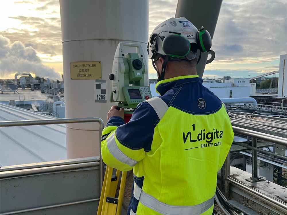
Method #1
Terrestrial scanning
Terrestrial scanning, also known as terrestrial laser scanning or terrestrial LiDAR scanning, is a specific type of laser scanning technology that is used for capturing highly detailed and accurate 3D data of objects, buildings, structures, and landscapes on the Earth’s surface. It involves the use of laser scanners positioned on the ground or on a tripod to capture the surrounding environment from various vantage points.
Terrestrial scanning works in a manner similar to other laser scanning techniques, such as airborne LiDAR or mobile LiDAR, but with the scanner placed at a fixed location on the ground.
How it works:
- Stationary Scanning: The terrestrial laser scanner is placed at a specific location on the ground or on a stable platform, such as a tripod. The scanner emits laser pulses, which cover a horizontal or vertical field of view.
- Laser Emission and Reflection: The laser pulses emitted by the scanner hit objects and surfaces within its line of sight. The laser light reflects back to the scanner’s sensors when it encounters objects or surfaces.
- Time-of-Flight Measurement: The scanner measures the time it takes for the laser pulses to return after hitting the target. This time-of-flight measurement allows the scanner to calculate the distance between itself and the objects or surfaces.
- Multiple Scans and Data Collection: To capture a comprehensive 3D representation of the surroundings, the scanner is rotated or moved to different positions. Each scan records millions of 3D points, and multiple scans are combined to create a dense point cloud.
- Point Cloud Generation: The collected 3D points are processed and combined to generate a point cloud. The point cloud represents the scanned objects and surfaces in 3D space and provides a detailed and accurate digital representation.
Terrestrial scanning is widely used in various industries and applications, including:
- Architecture and Construction: Terrestrial scanning is used for as-built documentation, renovation projects, and creating accurate 3D models of buildings and structures.
- Civil Engineering and Surveying: Terrestrial scanning is employed for topographic mapping, land surveying, and monitoring of construction sites.
- Cultural Heritage Preservation: Terrestrial scanning is used to document and preserve cultural heritage sites, historical buildings, and artifacts.
- Forensics and Accident Reconstruction: Terrestrial scanning assists in crime scene documentation and accident reconstruction by capturing detailed 3D data of the scene.
- Industrial and Manufacturing: Terrestrial scanning is used for quality control, inspection of large components, and reverse engineering.
Terrestrial scanning offers high accuracy and detailed data capture, making it a valuable tool for capturing precise 3D information of terrestrial environments, objects, and structures. It is widely used in various industries where accurate 3D data is essential for analysis, visualization, and decision-making.
Method #2
Mobile scanning
Mobile laser scanning, also known as mobile LiDAR (Light Detection and Ranging) scanning or mobile LiDAR mapping, is a technology that involves capturing 3D data of the surrounding environment while the scanning equipment is mounted on a moving vehicle. This enables the rapid and efficient collection of highly detailed and accurate 3D information of large areas, such as roads, highways, urban environments, and infrastructure corridors.
Mobile laser scanning works by equipping a vehicle with one or more laser scanners, GPS receivers, inertial measurement units (IMUs), and other sensors. The laser scanners emit laser pulses in multiple directions, covering a wide field of view around the vehicle.
How it works:
- Mounted on a Moving Platform: The laser scanners and other sensors are installed on a vehicle, such as a car, van, truck, or even a drone or railway cart. The vehicle moves through the area of interest at normal traffic speeds or predefined velocities.
- Laser Emission and Reflection: The laser scanners emit laser pulses in multiple directions horizontally and vertically. The laser beams hit objects and surfaces, and the light reflects back to the scanner’s sensors.
- Time-of-Flight Measurement: The mobile LiDAR system measures the time it takes for the laser pulses to return after hitting the target. The time-of-flight measurement allows the system to calculate the distance between the vehicle and the objects or surfaces in its vicinity.
- GPS and IMU Integration: The mobile laser scanning system integrates GPS data with the time-of-flight measurements to accurately georeference the 3D points. The IMU provides information about the vehicle’s orientation and motion, aiding in aligning the point cloud data.
- Data Fusion and Point Cloud Generation: The data from multiple laser scanners, GPS, and IMU are fused to create a comprehensive and georeferenced point cloud. The point cloud represents the 3D environment around the moving vehicle.
- Post-Processing and Analysis: The collected point cloud data can be post-processed and analyzed using specialized software. It can be used for applications such as mapping, surveying, asset inventory, urban planning, and infrastructure management.
Method #3
Photogrammetry
Photogrammetry is a remote sensing technique that involves extracting accurate 3D information of objects, landscapes, or environments from two-dimensional images. It utilizes the principles of geometry, optics, and image processing to measure the positions and dimensions of objects and create detailed 3D models or point clouds.
How it works:
- Image Acquisition: Multiple photographs of the object or scene of interest are captured from different angles or viewpoints using a camera. These images may be taken from the ground, from the air (aerial photogrammetry), or from space (satellite photogrammetry).
- Image Orientation: The images are processed to determine their precise positions and orientations relative to the object being photographed. This is achieved through the use of ground control points, GPS data, and camera calibration.
- Feature Matching: Corresponding points or features in multiple images are identified and matched. This is done by detecting common visual elements in the images, such as distinct landmarks or unique patterns.
- Triangulation: Using the matched feature points, photogrammetry applies triangulation principles to calculate the 3D coordinates of the points in the object space. Triangulation involves measuring the angles and distances between the camera positions and the points on the object.
- Point Cloud Generation: The 3D coordinates obtained from triangulation form a point cloud, which is a collection of 3D points representing the surface or structure of the object.
- Surface Reconstruction: Photogrammetry algorithms can further process the point cloud data to create a surface or mesh representation of the object. This surface model provides a detailed 3D representation.
Photogrammetry is widely used in various fields and applications, including:
- Topographic Mapping: Photogrammetry is used for mapping large areas of land, creating Digital Elevation Models (DEMs) and Digital Surface Models (DSMs).
- Architectural and Cultural Heritage Documentation: Photogrammetry is employed to document historical buildings, monuments, and artifacts, creating accurate 3D models for preservation and restoration purposes.
- Engineering and Construction: Photogrammetry is used for surveying, site planning, and monitoring construction progress.
- Agriculture and Forestry: Photogrammetry is used in precision agriculture and forest inventory to assess crop health and estimate tree volumes.
- Virtual Reality and Gaming: Photogrammetry is utilized to create realistic 3D environments and assets for virtual reality experiences and video games.
Photogrammetry is a versatile and powerful technique for generating detailed 3D data from images. It has become increasingly accessible with the advent of digital cameras and advanced image processing software, making it a valuable tool in a wide range of industries and applications.
Method #4
Drones
Drones, also known as Unmanned Aerial Vehicles (UAVs) or Unmanned Aircraft Systems (UAS), are increasingly being used in reality capture due to their ability to rapidly and efficiently collect high-resolution aerial imagery and data. Drones equipped with cameras and other sensors can capture images, LiDAR data, or photogrammetric data from different perspectives, providing valuable information for various applications.
How it works:
- Aerial Photography and Videography: Drones equipped with high-resolution cameras can capture aerial photographs and videos of landscapes, structures, and large areas. These images provide an overview of the site and can be used for visual inspection and documentation.
- Photogrammetry: Drones can be used for photogrammetry, a process of extracting 3D measurements and data from multiple overlapping images. By flying the drone over the target area and capturing images from different angles, photogrammetry software can create 3D models, point clouds, and orthomosaic maps.
- LiDAR Scanning: Some advanced drones are equipped with LiDAR sensors that emit laser pulses to measure distances and create highly accurate 3D point clouds. LiDAR-equipped drones are valuable for capturing detailed elevation data and terrain modeling.
- Reality Modeling and 3D Mapping: Drones are utilized to create reality models and 3D maps of various environments, including construction sites, landscapes, and historical sites. These models are used for design, analysis, and visualization purposes.
- Asset Inspection: Drones can be used for inspecting tall structures, such as bridges, towers, and wind turbines. They can access hard-to-reach areas and capture high-resolution images for condition assessment and maintenance planning.
- Agriculture and Forestry: Drones are employed in agriculture and forestry to monitor crops, assess plant health, and estimate vegetation coverage. This data aids in precision agriculture and forest management.
- Disaster Assessment and Relief: In the aftermath of natural disasters, drones can quickly survey affected areas, providing critical information for disaster assessment and relief efforts.
- Surveying and Mapping: Drones are increasingly used for land surveying and mapping applications. They can cover large areas in a short time, making them more efficient and cost-effective than traditional surveying methods.
- Construction Monitoring: Drones are used to monitor construction sites and track progress over time. Aerial images and data help construction managers assess project status, identify potential issues, and improve project coordination.
- Environmental Monitoring: Drones are employed in environmental studies to monitor ecosystems, wildlife, and natural resources. They can access remote and sensitive areas without disturbing the environment.
Drones have revolutionized reality capture by providing an agile, flexible, and cost-effective way to collect accurate and up-to-date data. Their applications extend across industries, enabling professionals to make informed decisions, improve efficiency, and enhance safety in various domains. However, it’s crucial to adhere to local regulations and safety guidelines while operating drones for reality capture purposes.
Interested?
Get in touch

Sami Kinttu
Interested?
Leave us a message
If you'd like to get in touch, leave us a message and we'll get back to you as soon as possible.